


« We Must Remember This | Main | Free Online Video of 'An Inconvenient Truth' Now Available »
Saturday, December 30, 2006
Record Snows!


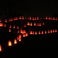
It's been snowing again in Albuquerque since yesterday morning, breaking records here and around the state. In our neighborhood in the NE Heights we have about 10-12 inches, making for some fabulous (and rare) sparkle scenes. People in colder, snowier parts of the nation might not be excited by these, but Albuquerque folks are always thrilled when it snows this much here in the high desert. We tend to get all mushy and romantic about it. Unless we're trying to drive somewhere that is....Last time I heard I-40 was still closed from here to the Texas border and I-25 from here to Colorado.
These are images from Mary Ellen's walks around the neighborhood last night and early this morning. She witnessed the fall of the big branch at our nearby park shown in the last photo and luckily wasn't standing closer when the weight of the wet, wet snow cracked it off and tossed it to the ground. (Click on images for larger versions.)
P.S. I see Duke City Fix has a link to a flickr photo group called Snow of the Century in Albuquerque that has a slew of fantastic shots taken by locals. Bravo!
And be sure to visit Taoseno FarrFeed's always riveting Fotofeed, which has a stunning collection of snow shots from Northern New Mexico spanning recent days. You can always visit Fotofeed via our link on the top right-hand sidebar on our main page.
There are even more snow shots at the Albuquerque flickr group worth a visit.
AREA FORECAST DISCUSSION
NATIONAL WEATHER SERVICE ALBUQUERQUE NM
257 PM MST SAT DEC 30 2006
RECORD BREAKING WINTER STORM CONTINUES TO PUMMEL PORTIONS OF NORTHERN NEW MEXICO. STORM TOTALS SO FAR ON THE ORDER OF 12-20 INCHES IN AND AROUND THE ABQ AREA WITH 18-26 INCHES IN AND AROUND SANTA FE. SOME PORTIONS OF THE EAST SLOPES OF THE SANGRE DE CRISTOS HAVE RECEIVED MORE THAN 30 INCHES OF SNOW. SNOW RATIOS APPEARED TO PAN OUT WITH 5-10 TO 1 FOR THE FIRST HALF OF THE STORM WITH 15-20 TO 1 FOR THE SECOND HALF. CAN ONLY IMAGINE IF ENTIRE STORM HAD BEEN ABOVE 10 TO 1. THE REAL HAZARD HOWEVER HAS BEEN IN AND AROUND THE CLAYTON AREA WHERE STRONG WIND AND HEAVY SNOW HAS CREATED DRIFTS TOPPING 10 FEET. WILL CONTINUE HEADLINES IN ALL AREAS WITH WRAP AROUND SNOWS AND DROPPED NORTHWEST PLATEAU...WEST CENTRAL AND SOUTHWEST MTNS. ADDITIONAL LIGHT TO MODERATE SNOWFALL ACCUMULATIONS ACROSS THE ABQ AND SAF AREAS ALONG WITH NE PLAINS OVERNIGHT WILL MAKE THIS STORM ONE TO REMEMBER FOR QUITE SOME TIME!
(If you missed them, here's some from our earlier post on the storm we had before Xmas and the icy aftermath.)
December 30, 2006 at 12:05 PM in Visuals | Permalink
Comments
Fabulous shots-thanks! I think we got about 10" in the near North Valley.
Posted by: david | Dec 30, 2006 4:07:43 PM
Love the snow! Even though it made getting out of anywhere I parked rather difficult.
Posted by: | Dec 31, 2006 1:03:42 AM
Bailey and I are totally jealous. I love snow!
Posted by: KathyF | Dec 31, 2006 9:32:48 AM